Skeo builds innovative, cutting-edge deliverables using Esri ArcGIS Online (AGOL) and integrating features such as custom mapping applications, interactive and animated PDFs, videos and closed captioning, scalable vector graphics, social media and web-accessible databases that enrich users’ experiences.
GIS Geospatial Mapping
Overview
Our team has expertise in conducting detailed and complex GIS and data analysis and presenting results in a range of formats including print maps, StoryMaps, online interactive applications and dashboards to address client priorities.
Land Use Planning
Our geospatial visualizations are used to provide insights for communities, stakeholders and decision-makers on how land uses, natural and physical features, infrastructure, connectivity, property ownership configurations and contamination can inform more sustainable, equitable and resilient development and economic opportunity.
Our process focuses on creating compelling tools—such as suitability zones and reuse maps, heat maps of risk factors, interactive StoryMaps, and service accessibility maps—to highlight trends, patterns and insights not otherwise easily seen. With this flexible approach, we can efficiently identify suitable options to achieve location-specific reuse and resiliency goals.
Government Programs
Skeo’s GIS staff excel at integrating technical expertise with knowledge of local, state and federal government programs to develop innovative and forward-thinking solutions to address agency challenges and priorities including environmental justice and climate resiliency. Our dynamic mapping products clearly communicate complex local conditions, supporting decision-making and facilitating collaboration among stakeholders. We have applied EPA’s Superfund and RCRA GIS data schema standard to thousands of regulatory site features, giving us valuable experience in creating high-quality GIS data that meets government requirements and builds foundational data sets for mapping products. Our expertise with data sets like EPA’s EJSCREEN and NOAA’s climate models as well as industry-standard GIS tools such as scripting languages and ArcGIS Enterprise allows us to provide inventive and well-informed approaches to address management priorities. Our GIS application developers are well-versed in EPA GeoPlatform standards and best practices and efficiently create visually stunning interactive communication tools that inform, inspire and encourage engagement.
To streamline workflows and reduce client workload, Skeo develops dynamic process automation tools across a range of platforms including Microsoft PowerAutomate and Sharepoint, AGOL and Survey123.
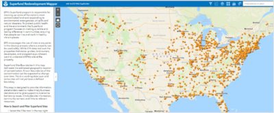
Superfund Redevelopment Mapper
Skeo fully supported the development of EPA’s Superfund Redevelopment Mapper: a new GIS-based tool that significantly bolsters the ability of local, state and tribal governments, community development organizations and professional developers to explore reusing abandoned land and revitalize underserved communities on or near formerly- contaminated Superfund sites. The tool compiled 21 data sets from five main sources: EPA, Homeland Infrastructure Foundation-Level Data (HIFLD) database, U.S. Census Bureau, Esri, and Federal Emergency Management Agency (FEMA). Additional proximity metrics were calculated using GIS to highlight the characteristics of each site included in the Superfund National Priorities List (NPL) and within the Superfund Alternative Approach (SAA). Finally, a Web Mapping Application was built on EPA’s Geoplatform with functionality to maximize the interactive features. The result is a user-friendly app that provides users with Superfund site locations, data layers that highlight the characteristics of a property and surrounding areas, and the ability to explore more information about their communities such as income levels, unemployment numbers and land features. It also provides key information to help stakeholders make informed business decisions about land reuse that align with community needs and priorities.

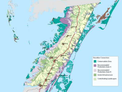
Chesapeake Bay Gaps in Green Space Map Tool
Funded by EPA and in partnership with the Chesapeake Bay Trust, Skeo is supporting development of a map tool to help conservation and community organizations identify low-income communities of color with limited green space. Skeo conducted a literature and online review to identify potential data sources and precedents. Skeo then worked with an Advisory Group formed by the Chesapeake Conservancy Partnership to identify data sources and metrics for developing preliminary map sets. Skeo is hosting three community listening sessions to review and provide feedback on the map set, including data sources, metrics and representation. Ultimately this map set will be posted on the Chesapeake Conservancy and Chesapeake Bay Program websites as an application that will allow the user to turn on relevant layers and base maps as well as import data layers specific to their conservation goals. The goal is for community and conservation groups to use the map sets to identify areas in the Chesapeake Bay with limited or no green space and make investments to increase green space for low-income, communities of color.